

The unsettled weather pattern will persist of the Palmetto State this week, as severe thunderstorms become increasingly possible on Wednesday and Thursday. This storm threat follows a weekend of flooding rain.
On Friday, a coastal low and a humid atmosphere set the stage for widespread thunderstorm activity, especially along the I-95 corridor. This low quickly developed into Tropical Storm Colin overnight Friday into Saturday, and the system supported continued showers over the eastern half of the state through Saturday evening. By Sunday and Monday, a front began to dip into the region from the north-northwest. Energy from the boundary enabled rounds of storms to develop, and the moisture rich atmosphere overhead provided the fuel for heavy rain rates.
Flooding was quite widespread across the Grand Strand today with rainfall totals between 4 and 6 inches in many spots between Murrells Inlet and Myrtle Beach. #flooding #scwx #ilmwx pic.twitter.com/gSFvrrqsQy
— NWS Wilmington NC (@NWSWilmingtonNC) July 5, 2022
Between Friday and Monday, over a half a foot of rain fell in some parts of the state. Observational data indicate that most of these accumulations occurred within a short period of time. For example, near Columbia, a station reported over 8.5 inches of rain between Friday and Monday night. Of that, 2.9 inches fell on Saturday, and 5.5 inches fell on Independence Day. Such heavy accumulations over a short period of time caused flash flooding in some parts of the capital. Similar situations of heavy rainfall over a short period of time occurred along the Grand Strand and Pee Dee this past weekend.
This week, the active pattern will likely continue as yet another system tracks through the Ohio Valley and Northeast. Although the main frontal boundary associated with this week’s storm should remain well to our north, energy and moisture are forecasted to be ample enough to support numerous strong thunderstorms. In addition to excessive rain rates and the potential for more flash flooding, storms could become strong enough to produce damaging winds and large hail.

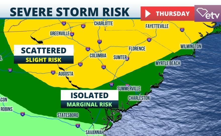
As of Tuesday morning, model guidance suggests that the greatest threat for these storms will occur on Wednesday, especially over the northern third of the state, and Thursday. On both Wednesday and Thursday, meteorologists have classified parts of South Carolina under a slight risk, or level two out of five, for severe thunderstorms.
Residents are urged to monitor the latest forecasts and adjust plans as necessary. Should alerts be issued for your immediate area, take appropriate safety/sheltering actions.