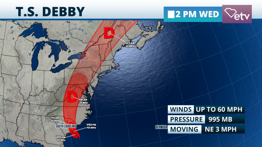
Heavy rainfall is still expected across parts of South Carolina through the Mid-Atlantic for the next 48 hours. Tropical storm, Debby continues to be stationary, under specific meteorological parameters, and it’s likely to remain traveling less than 5 mph through early Thursday morning. Debby will start to make a turn toward the northwest on Wednesday night into early Thursday morning. It is expected to be back on land, over South Carolina by sunrise Thursday. This would mark Debby’s second official landfall. The first landfall was near Steinhatchee, Florida early Monday morning. The most impact will now affect the Pee Dee and northern Midlands. Keep in mind that the Pee Dee´s coast will still deal with storm surge of up to 3 feet.
An early morning satellite imagery showed very dry air filtering into the western portion of Debby. This was good news as the rain remained less intense for the first part of the day on Wednesday. But remember, Debby, will make a turn, and heavy rainfall is said to continue through Thursday. This is not a time to let your guard down.
Also, Debby will continue to gain a little bit of strength and it may reach 70 mph before making landfall Thursday morning. After Debby makes landfall expect the maximum sustained winds to gradually weaken as it moves inland. Although Debby is moving slowly this Wednesday once it makes the turn toward South Carolina and moves inland. Its forward speed is expected to increase, and the system will be traveling over the Mid-Atlantic and through the Northeast throughout the rest of the week.

As Debby makes it turn toward South Carolina again we expect the tornado risk to increase during the evening hours. Large swells, rough seas, and a high risk of rip currents will continue. Please stay out of the water.
How much more rain?
Additional rainfall from Debby across South Carolina will range between 3 to 9 inches. Some isolated spots could receive an additional 15 inches of rain. Southeastern Georgia could receive between 1 to 2 inches of additional rain through Thursday. Parts of the mid-Atlantic, including Virginia could receive up to 10 inches of rain in some spots through Friday. There’s a high flood risk across the area including the risk of flash floods and urban flooding. Rivers will also increase their levels, perhaps rapidly. As Debby moves away, there will still be rivers and creeks increasing their levels. The National Weather Services informed residents during their Wednesday afternoon conference that rivers are expected to reach their crest by the middle of next week.
As Debby continues to move through Northeast parts of upstate New York and Vermont could count for up to 6 inches of rainfall in some spots.

We continue to monitor this system closely please turn in to our radio and TV stations for the latest on what’s happening in South Carolina.
SCETV website https://www.scetv.org/stream/tropical-storm-debby-updateYouTube - https://www.youtube.com/live/MHI5uTA2FNE?feature=sharedFacebook - https://facebook.com/events/813718147225030/


