
-
 World Meteorological SocietyAs the countdown to Atlantic hurricane season begins, South Carolina emergency management offices across South Carolina are sharing vital safety guidelines to empower residents to stay ahead of potential storms.
 -
 Approaching system to elevate risk for strong storms Tuesday night, Wednesday


-

-
 Several inches of rain expected through Saturday evening, raising concerns for flash flooding
 -
 Sub freezing lows are forecasted throughout the state both Friday night and Saturday night. Some areas could experience temperatures as low as the single digits.
 -
 A fast-moving severe weather system will develop over the Southeast Thursday evening and may continue rapidly moving across the Carolinas Friday and Friday evening, following Tuesday’s storm conditions. Residents should take necessary precautions to protect their homes before conditions develop.
 -

-
-
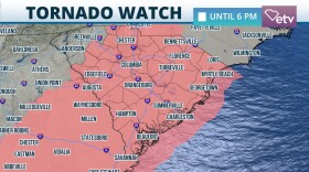
 The areas of greatest concern for severe thunderstorms are the Lowcountry, Pee Dee and much of the Midlands, including Columbia, where the Storm Prediction Center places an ENHANCED risk of severe weather, a level 3 out of 5.
 -
 Powerful storm system with damaging winds and tornadoes possible Tuesday
 -
 A strong storm system will be sweeping through a large part of the country this weekend.
 -
 Parts of South Carolina were met with widespread rainfall, near gale force winds and a tornado on Sunday.


