-
 South Carolina has seen just three June tropical cyclone landfalls since 1851, with no system stronger than a Category 1 hurricane.
 -
 During an average year, the Atlantic Basin sees 14 named storms, seven hurricanes and three major hurricanes. The list of names for the 2026 Atlantic hurricane season starts with Arthur.
 -
 NOAA’s outlook for the 2026 Atlantic hurricane season predicts below-normal activity as an impending El Niño will lead to increased wind shear across the basin.
 -
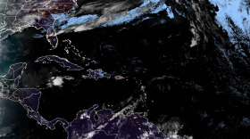
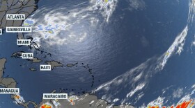 The National Hurricane Center released its first daily outlook for the Atlantic, Caribbean and Gulf on Friday which showed no tropical activity was expected over the next week.
 -
 The first named cyclone in the Atlantic basin typically forms around June 20, with meteorologists tracking the first hurricane by Aug. 11. The first named storm will be Arthur.
 -
 With the 2026 Atlantic hurricane season less than a month away, South Carolina officials are urging residents to prepare now as part of Hurricane Preparedness Month.
 -
 Forecasters expect tropical cyclone activity could resemble seasons in 2006, 2009, 2015 and 2023. El Nino plays a prominent role in each of the seasons.
 -
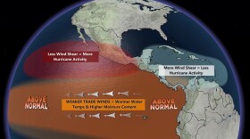 La Niña officially emerged in September 2025 and lasted until April. Neutral conditions are present, but a El Niño is expected to emerge later in 2026.
 -
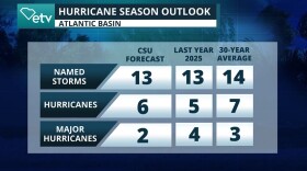 Colorado State University’s 2026 Atlantic hurricane season outlook calls for below-normal activity across the Atlantic basin due to a likely transition into an El Niño.
 -
 The National Hurricane Center is rolling out upgraded products for the 2026 hurricane season, including a redesigned cone graphic, new storm surge tools and improved access for mobile users.
© 2026 South Carolina Public Radio

Play Live Radio
Next Up:
0:00
0:00
Available On Air Stations


