
Irene Sans
Meteorologist-
 Colorado State lowers its 2026 Hurricane Season forecast due to a strong El Niño developing during the season. What does this mean?
 -
 Families and caregivers of neurodivergent children face unique challenges during emergencies. Now, a team of moms is partnering with the cities and organizations to host an autism-friendly emergency preparedness workshop—showing how a specially designed backpack with tailored tools can help reduce stress when it matters most.
 -
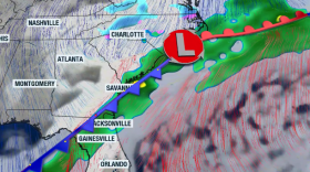
 Flash flooding claims more than 140 deaths annually statewide, and this is just one of the three types of flooding that impact the Palmetto State.
 -
 It’s the time of the year, ding! Your car’s tire pressure sensor light is on! You can blame it on the weather.
 -
 Two cold fronts are expected to cross the Palmetto State this week. Temperatures will remain well-below-average to end the week and into the weekend. Strong winds, too! There is a warm-up on the horizon.
 -
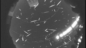 The Geminids is the most active meteor shower of the year and it peaks tonight. Will clouds allow visibility? If not, could they still be watched later this week?
 -
 The cold blast has brought more than just cold! Many are dealing with low tire pressure.. and it's all about the weather.
 -
 The big winter (and popular) topic is dusted off very early this season as frigid air plunges south for Veterans' Day. But what is the Polar Vortex, exactly?
 -
 Melissa is now traveling over Cuba, with strong, violent winds and extreme rainfall. Up to 16 inches of rain is possible for eastern Cuba.
 -
 Melissa is a monster, and images start to emerge as Melissa moves through the island: landslides, flash floods, storm surge, and violent winds.


