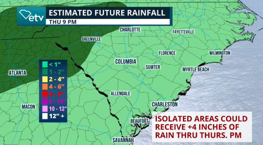
Soggy weather continues across South Carolina through the middle of the week. Columbia has recorded rain 12 of the last 13 days. This week, we continue to be under the influence of a trough attached to a weak, low-pressure system that is traveling across the Atlantic. The heavy periods of rain will continue throughout the day on Wednesday, with the main movement of the showers from west to east. The showers will not be organized; therefore, even though most will be moving from west to east, many places will get intermittent showers throughout the day.

The morning will start with a few passing light showers across upstate and the coast. By the late afternoon, the radar shows a few light showers moving along the I-95 corridor as well through I-20 and Columbia.

By the afternoon, a few thunderstorms will be forming across the Lowcountry, and the day will end with a few more showers and thunderstorms moving from west to east, this time pushing through the Upstate and the Midlands. There could be some more substantial downpours along I-20 extending from Augusta, Georgia, through Columbia and Bennettsville between 8 p.m. and 10 p.m.

For Thursday, we are expecting a soggy start to the day across much of the Midlands. The trough will continue to dominate our region, and even though we’ll be pulling away to the north, a lot of instability, combined with a southwesterly flow, bringing in lots of tropical moisture from the Gulf, will produce numerous showers throughout the day. There’s also that risk for thunderstorms to develop. The ground is ready, well saturated from all these rains; therefore, a marginal risk for flash floods stays in effect through Friday morning, especially for poor drainage and low areas.

The good news is that we are on a drying trend. There’s a high-pressure system in the middle levels of the atmosphere that will start to suppress the rain and thunderstorm chances across much of the state. For Friday, there will be a few scattered showers pushing through the state at different times of the day. But overall, and compared to recent days, the coverage will be minimal. Still, the Weather Prediction Center holds a marginal risk for flash floods due to the grounds being saturated from recent rains, and any stronger downpours could exacerbate flooding.

So far, the weekend looks closer to average conditions for the summertime. Scattered thunderstorms will be mainly confined along the coast as the temperatures will be between the upper 80s and low 90s, and any storm development will be driven by the sea breeze.
For the rest of the state, with more sunshine, warmer temperatures will also return. The Midlands will go from having temperatures in the low to mid-80s to temperatures in the low 90s by Friday. Places like Augusta and Columbia could reach 92° in the afternoon. The Upstate region will also go from having temperatures around the mid-80s to temperatures closer to 90°F on Friday, and much of the area will be hitting 90°F on Sunday, under mostly sunny skies with a very low chance for a scattered shower, especially after 5 p.m.
We will bring you a tropical update on Wednesday. Erin is over 3000 miles away from the United States and currently does not represent a threat to land.


