

The first significant fall frontal boundary of the season is expected to pass through the state during the second half of the workweek, bringing scattered showers and sending temperatures down to their coolest levels since March.
Forecast models show the bulk of the precipitation will occur Wednesday into early Thursday, but rainfall totals are expected to accumulate to less than an inch.
The heaviest rainfall will tend to be along the coast and near the South Carolina–North Carolina border, but most activity will remain below severe criteria.
Once the cold front passes through, winds are expected to gust upwards of 20 to 30 mph, helping to drive in the cooler air.
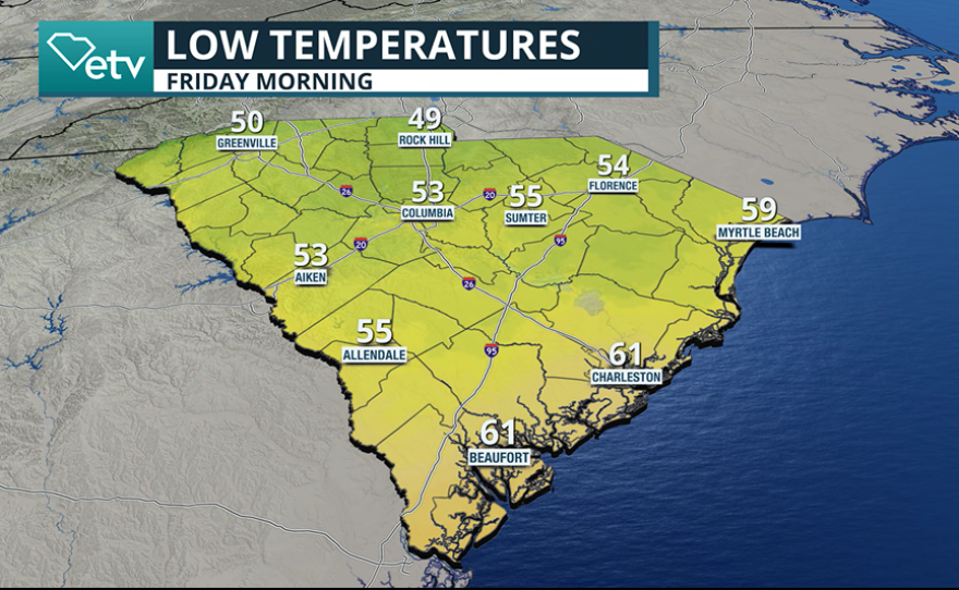
While Thursday’s temperatures will run 10 to 15 degrees cooler than Wednesday’s warm highs, the coolest conditions are expected on Friday, when most of the Palmetto State will start the morning off in the 40s and 50s and only warm to a few degrees below or above 70.

Once the winds ease, the weather could be described as “Chamber of Commerce,” offering ideal opportunities to enjoy fall foliage at some of the state’s highest elevations around Table Rock State Park, north of Greenville.
For parts of the Upstate, Friday could be the coolest day since March 17, when the afternoon high temperature reached only 59 degrees.
Even though the weather will feel cool, temperatures will remain above frost levels, which usually don't occur until November.

A ridge of high pressure will remain the dominant feature through the weekend, keeping skies generally clear and conditions dry west of Interstate 95. However, for communities along the coast, all eyes will remain on the lingering frontal boundary and its next movement.
Coastal Threats Linger
The past two weeks have been rough along the immediate coastline — first with the swell from Hurricane Imelda, then a King Tide event, and now the frontal boundary, which could be a prelude to a developing coastal storm capable of bringing more coastal flooding and erosion.
Frontal boundaries are common ignition sources for tropical cyclones, especially during the final weeks of the hurricane season, when water temperatures are still warm enough to aide in organization.
While the exact evolution remains uncertain, global forecast models suggest the system could develop into a hybrid-type storm rather than a purely tropical cyclone, though the impacts would largely be the same.

Rough seas, beach erosion and blustery conditions are expected to persist through the weekend along the immediate coastline and be more significant around the Grand Strand versus the Savannah River Valley.
While the National Hurricane Center will continue to monitor the region, the next tropical cyclone to earn a name will likely form from Invest 95L, located more than 1,000 miles east of the Caribbean islands.
Computer forecast models indicate that while “Jerry” could become a significant cyclone, but it is expected to remain well east of the U.S. mainland.
