-
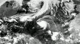
With the 2026 Atlantic hurricane season less than a month away, South Carolina officials are urging residents to prepare now as part of Hurricane Preparedness Month.
-
A widespread rainfall event is likely across the Carolinas from late on Friday through Saturday, with some areas that could pick up an inch of much-needed rain.
-
Air quality values across South Carolina are expected to remain mostly in the good range this week, with only a brief window of concern Tuesday and Wednesday.
-
The prevailing wind flow out of the south and west is helping to send smoke from wildfires burning in Georgia and Florida into South Carolina.
-
Drought conditions across South Carolina are rapidly expanding, with more than 97% of the state now officially in a drought. Little to no rainfall is expected during the coming weeks.
-
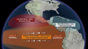
A forecasted "super" El Niño later this year could have important implications for South Carolina, especially beyond hurricane season. While it can work against Atlantic storms, it also tends to favor a stormier/wetter winter across the Southeast.
-
A heat dome over the Southeast is pushing temperatures into the 80s and 90s across the Palmetto State.
-
Forecasters expect tropical cyclone activity could resemble seasons in 2006, 2009, 2015 and 2023. El Nino plays a prominent role in each of the seasons.
-
Colorado State University may be landlocked, but its seasonal hurricane forecast is closely watched in South Carolina, where storms like Hugo, Ian, and Idalia show how vulnerable the coast remains.
-
La Niña officially emerged in September 2025 and lasted until April. Neutral conditions are present, but a El Niño is expected to emerge later in 2026.

Play Live Radio
Next Up:
0:00
0:00
Available On Air Stations


