-
 South Carolina has historically seen limited tropical impacts during July. Tropical Storm Chantal impacted the region in 2025 and Hurricane Bob made landfall in 1985.
 -
 Data from the South Carolina Department of Public Health shows the highest annual number of heat-related hospitalizations occur in Richland, Horry, Greenville, Charleston and Lexington counties.
 -
 Warmer weather is returning to South Carolina over the weekend which will result in air temperatures near 100 degrees and heat indices in excess of 104 degrees.
 -
 South Carolina officially entered astronomical summer on June 21, marking the longest day of the year.
 -
 South Carolina will be the subject of beneficial rain as tropical moisture from the Gulf impacts the state on Thursday and Friday.
 -
 South Carolina is known for its hot, humid summers with the Columbia setting the state's all-time heat record at 113 degrees Fahrenheit.
 -
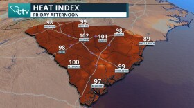 An early-season heat wave will send temperatures into the upper 90s across South Carolina this weekend. The heat could lead to significant health impacts.
 -
 Colorado State lowers its 2026 Hurricane Season forecast due to a strong El Niño developing during the season. What does this mean?
 -
 Since reliable global temperature records began in the 1950s, Earth's warmest years have occurred during El Niño events, while the coolest years have typically coincided with La Niña conditions.
 -
 Front slides in tonight through South Carolina. Temperatures drop slightly, then ehat ramps up. Winds will shift.
© 2026 South Carolina Public Radio

Play Live Radio
Next Up:
0:00
0:00
Available On Air Stations


