The combination of king tides and a significant onshore flow has once again caused scenes of flooding in Charleston - a problem the region has battled for more than 300 years.
The city of over 150,000 residents sits on a low-lying peninsula surrounded by rivers and the Atlantic Ocean, meaning that even minor increases in water levels can quickly become problematic.
For centuries, Charleston has attempted to control flooding through drainage systems, sea walls and water. Yet the challenge remains the same: how do you drain a city that sits only a few feet above sea level and is nearly surrounded by water?
According to NOAA’s National Centers for Coastal Ocean Science, Charleston experienced flooding just two days a year around 1950, totaling roughly four hours. By 2014, that number climbed to 25 days and more than 40 hours of inundation. By 2051, high-tide flooding is expected to occur up to 60 days per year, with potentially more than 100 hours annually.

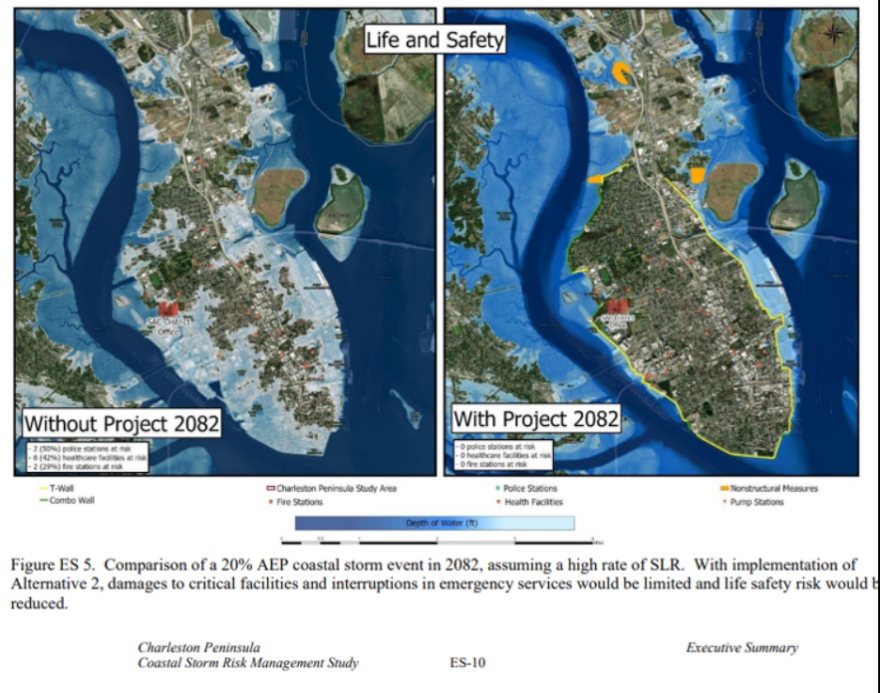
To combat the growing threat, the U.S. Army Corps of Engineers and local officials unveiled the Peninsula Perimeter Protection Project - a more than $1 billion plan to build a nearly nine-mile-long, 12-foot-high storm surge wall around part of the city’s peninsula.
The plan includes watertight gates, pump stations and barriers along major waterways, all designed to keep out storm surge and extreme high tides. Additionally, dozens of structures would be elevated in an effort to minimize flooding impacts.
According to the Army Corps, the project could significantly reduce storm damage by safeguarding vital facilities, historic landmarks and emergency access routes. However, the proposal still requires congressional approval and funding before the construction phase can begin, and the timeline for any such action remains uncertain.
Due to the ongoing federal government shutdown, a spokesperson for the Army Corps was prohibited from answering questions about the agency’s projects, including the status of the proposed Charleston seawall plan.

“The BCR [Benefit Cost Ratio], which implies that for every dollar spent on the project the federal government and the City would save $10.80 in avoided damages and financial losses, is the highest for a project of its kind in the nation,” the city previously stated about the proposal.
Local emergency management officials emphasize that, while questions remain about the project’s future, the city is not relying solely on one solution.
Multiple efforts are underway or planned to strengthen flood resilience, including enhancing seawalls, increasing drainage tunnel capacity and adding new water pumps - totaling at least half a billion dollars in additional investments.
What remains unclear is whether these efforts will produce widespread flooding prevention or be limited in scope.
Charleston is one of the fastest-sinking communities along the East Coast, which is adding to the dilemma.
A study by Virginia Tech’s Earth Observation and Innovation Lab found the city is subsiding about four millimeters per year - a rate influenced by both natural shifts in terrain and human activities, such as groundwater extraction.
The slow but steady sinking makes the region even more susceptible to flooding, even without a major storm or a heavy rainfall event.


