-
 Flash flooding claims more than 140 deaths annually statewide, and this is just one of the three types of flooding that impact the Palmetto State.
 -
 The National Weather Service advises that a Tornado Watch is in effect until 1 p.m. Thursday for a number of counties in the state. Meteorologists also are keeping track of tornado warnings and other severe weather alerts.
 -
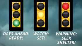 South Carolina officials are highlighting storm preparedness and communication during the state's weather safety week.
 -
 Roller coaster-like weather is helping to enhance pollen readings across the state with elm, juniper, pine and being the top allergens.
 -
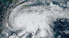 The WMO has retired the name Melissa from its Atlantic basin naming lists after the Category 5 system became the strongest hurricane on record to make landfall in Jamaica.
 -
 The South Carolina Emergency Management Division is partnering with the National Weather Service and the South Carolina Department of Natural Resources to promote awareness of the dangers associated with severe storms, tornadoes and flash flooding, while urging South Carolinians to take appropriate steps to stay safe.
 -
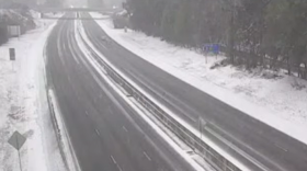 Data from the Southeast Regional Climate Center, shows that South Carolina had a cooler and drier winter than is typical despite at least two winter storms and an Arctic blast of cold air.
 -
 It’s the time of the year, ding! Your car’s tire pressure sensor light is on! You can blame it on the weather.
 -
 The National Hurricane Center is expanding its use of artificial intelligence tools to enhance hurricane tracking and intensity forecasts. The 2026 hurricane season will begin on June 1, 2026.
 -
 Model guidance uses data from the first blooms of the cloned lilac cultivar and two cloned honeysuckle cultivars to determine the leaf out process.
© 2026 South Carolina Public Radio

Play Live Radio
Next Up:
0:00
0:00
Available On Air Stations


