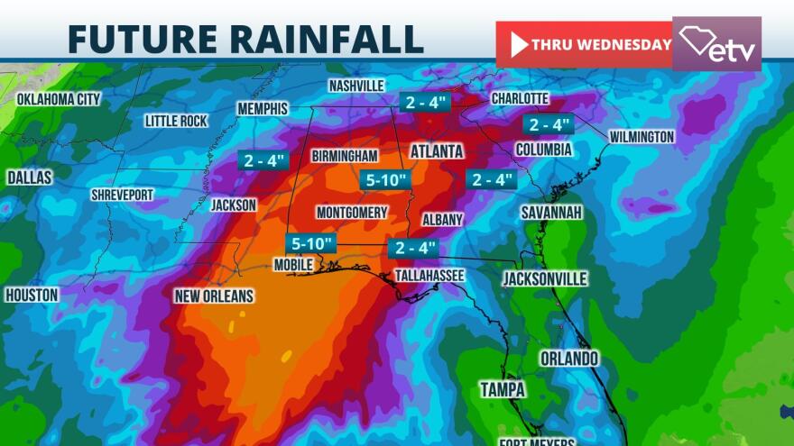
Heavy rainfall is likely to cause areas of flash flooding across portions of the Palmetto State this weekend in advance of a tropical system approaching from the Gulf of Mexico.
As of Friday morning, the National Hurricane Center called the system "Potential Tropical Cyclone 3" in anticipation of the system receiving a tropical depression or tropical storm classification later Friday or Friday night. It is moving toward the north at a steady clip, near 14 mph. The track of the eventual tropical depression or tropical storm will take it to near the Louisiana coastline early Saturday morning.
As is often the case with early season tropical systems, strong wind shear and dry air will likely prevent the storm from strengthening too dramatically. Most of the inclement weather will be east of the center, resulting in Tropical Storm Warnings from Intracoastal City, Louisiana to the western Florida Panhandle. Heavy rain and inland flash flooding, wind gusts to tropical storm force, and minor coastal erosion are expected within the warning area as the storm approaches Friday night and Saturday.

Rain from the tropical system is likely to start near the Savannah River Saturday afternoon or evening. However, most of the rain will move into the Palmetto State Saturday night into Sunday. Rainfall amounts of 2 to 4 inches, with locally higher amounts, are forecast over the Midlands and Upstate. One-half to 2 inches of rain are most likely over the Lowcountry, Grand Strand, and Pee Dee regions. The rain is likely to be beneficial, particularly over the eastern half of the state, where drought conditions developed in May and early June. Pockets of flash flooding are somewhat more likely in the Midlands and Upstate where heavier rain is more probable and conditions have been a little wetter during the spring months.
Isolated tornadoes may develop on Sunday when the remnant of the tropical system passes closest to the state. Many of these tornadoes, should they develop, are likely to be short-lived.
The tropical system will accelerate toward the northeast and off the Atlantic coast Sunday night. The rain should gradually diminish, but the approach of a front next week will bring another round of showers and thunderstorms to the state.


