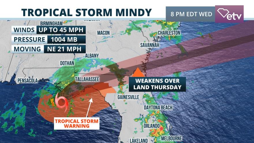
Wednesday 5 pm EDT Update:
The disturbance referenced as "91L" in the original story below quickly become better organized Wednesday afternoon, eventually intensifying to become Tropical Storm Mindy by early evening. A Tropical Storm Warning was issued for coastal Wakulla, Gulf, Franklin, Lafayette, Jefferson and Taylor counties. Winds gusts up to 45 mph are likely in the aforementioned areas when the strongest rain bands from Mindy rotate through. Tropical Storm Mindy is forecast to move inland overnight and weaken quickly across northern Florida and southeast Georgia Thursday.
Projected impacts to South Carolina from Tropical Storm Mindy (formerly disturbance "91L") have not changed, and are detailed below.
Original story published Wednesday morning:
No strong tropical systems are affecting South Carolina directly, but impacts from a disturbance in the Gulf and Hurricane Larry well offshore are making their presence known.
Heavy rain from what forecasters are calling Disturbance "91L" have prompted Flash Flood Watches for portions of the Florida Panhandle through Thursday morning. The National Hurricane Center says there is still a chance it could become a tropical or subtropical depression or named storm before moving inland over the Florida Panhandle Wednesday evening.
"91L" will have a second opportunity to develop off the South Carolina coast on Thursday and Friday. Regardless of development, it is likely to generate showers near the coast, along with rough water conditions and minor coastal flooding near the time of high tide around Charleston. The disturbance is expected to head out to sea over the weekend, with little additional impact on the U.S. coastline over the upcoming weekend.
Hurricane Larry weakened slightly to a category 2 hurricane about 500 miles southeast of Bermuda as of late Wednesday morning. Its large size has already generated swell that is reaching the east coast of the United States. There is a moderate to high risk of rip currents along many Atlantic beaches Wednesday, which is expected to last through Friday before conditions improve over the weekend. The center of Larry is expected to pass east of Bermuda, but a Tropical Storm Warning is in effect for the island because of the expansive area of tropical storm winds that are likely to still reach the island on Thursday.
Another area of disturbed weather is expected to emerge from Africa this weekend. It could develop near the Cabo Verde Islands late this weekend or early next week.


