

-
 In South Carolina, tropical damage is not always driven by the center of a storm. Tornadoes embedded in rain bands and widespread tree damage can create some of the most disruptive impacts, even far inland.
 -
 In South Carolina, hurricane impacts are not always measured by wind speed or rainfall totals. Flooded roads, damaged infrastructure, and blocked access routes can isolate communities before, during, and after a storm — turning mobility itself into part of the emergency.


-
 In South Carolina, a tropical system can begin as a coastal threat and quickly turn into an inland flood disaster. Heavy rainfall, swollen rivers, blocked highways, and tree damage often become the defining impacts well away from the beach.
 -
 South Carolina has seen just three June tropical cyclone landfalls since 1851, with no system stronger than a Category 1 hurricane.
 -
 In South Carolina, hurricane risk is not confined to the coast. Storms can bring surge, tornadoes, blocked roads, major outages, and infrastructure damage far inland, making statewide impacts a major part of the story.
 -
 During an average year, the Atlantic Basin sees 14 named storms, seven hurricanes and three major hurricanes. The list of names for the 2026 Atlantic hurricane season starts with Arthur.
 -
 NOAA’s outlook for the 2026 Atlantic hurricane season predicts below-normal activity as an impending El Niño will lead to increased wind shear across the basin.
 -
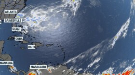 The National Hurricane Center released its first daily outlook for the Atlantic, Caribbean and Gulf on Friday which showed no tropical activity was expected over the next week.
 -
 Hurricane preparation works best when it begins before the season ever tests it—even a small step now can lower risk and reduce pressure later.
 -
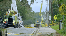 Clear skies can be misleading. In South Carolina, some of the most dangerous hurricane hazards begin after the storm—during cleanup, return, and recovery.
 -
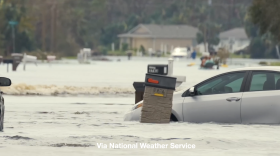 During storm season focusing on protection during the storm is mission critical. And in South Carolina, that can mean wind, water, and tornadoes all unfolding at the same time.
 -
 When a storm threatens South Carolina, early action matters because roads flood quickly, evacuations take time, and conditions can deteriorate before landfall.


