While many across South Carolina may dream of a white Christmas, the odds of seeing snowfall on December 25 are quite slim.
Over the last 50 years, there have been less than a handful of Christmases that have featured at least an inch of snowfall on the ground.
The needed setup for frozen precipitation in South Carolina is complex - an event that requires the right atmospheric ingredients to come together at just the right time.
The region typically needs a two-part sequence of events: a powerful storm system ushering in a surge of cold air, followed by a secondary system that can produce precipitation while temperatures are near or below freezing.
Because South Carolina’s climate is largely influenced by what comes out of the south and west, winter weather events are more common later in the winter season, reducing the likelihood of December snowfall.

Every year, Greenville averages nearly 5 inches of snowfall, while Columbia typically sees around 1 inch, with most accumulations occurring in January and February, when colder airmasses are in place.
Coastal communities such as Charleston and Myrtle Beach record even fewer amounts of snowfall, with flakes only reported about once out of every three years.
According to NOAA climate data, areas around the Appalachian Mountains - just a short drive from the Upstate - stand a better chance at seeing a white Christmas.
Communities in the higher elevations of western North Carolina, eastern Tennessee and western Virginia have a 10-25% chance of snow on the ground on December 25.
To find areas where the odds rise above 50%, one must travel much farther north, generally above Interstate 80, across the Upper Midwest and interior Northeast.
Here's a look at three most recent Christmas-time snow events in South Carolina during the last half-century:
2020 - Last snowy Christmas in the Carolinas
The heaviest accumulations were in the Ohio and Tennessee valleys, but some border areas in South Carolina reported snow showers on Christmas Day.
A limited precipitation field prevented major population centers from seeing snowfall.

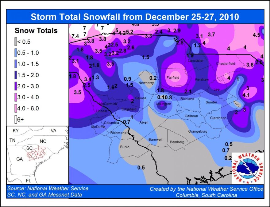
2010 - Last extensive holiday season snow event
While South Carolina was spared from the worst of the North American blizzard, local communities saw their heaviest holiday accumulations in decades.
The system organized into a major nor’easter while off the coast of the Carolinas, but enough wraparound moisture existed for frozen precipitation.

Locales along the S.C.–N.C. border reported amounts generally between 3-7", while most areas west of I-95 maxed out in the 1-2-inch realm.
Major cities along the I-95 corridor in the Northeast reported between 1-3 feet of snowfall with higher drifts.
1989 - Historic Christmas week snowstorm
The historic storm system developed over the Gulf before moving across Florida and the coast of the Carolinas.
Myrtle Beach reported a whopping 14", Charleston saw 8", while Walterboro reported just over 4" - setting local snowfall records.
According to the National Weather Service, the winter weather event caused widespread power outages and severe crop damage.

It was the snowiest holiday week since the winter of 1969, and the event is widely remembered as the most extraordinary southern snowstorms of all-time.


