

South Carolina and much of the eastern half of the nation are bracing for a blast of Arctic air during the upcoming workweek, which will result in temperatures plunging to their coldest levels so far this season.
A potent cold front is forecast to cross through South Carolina on Sunday, ushering in frigid air that will settle in by Sunday night and linger through Tuesday.
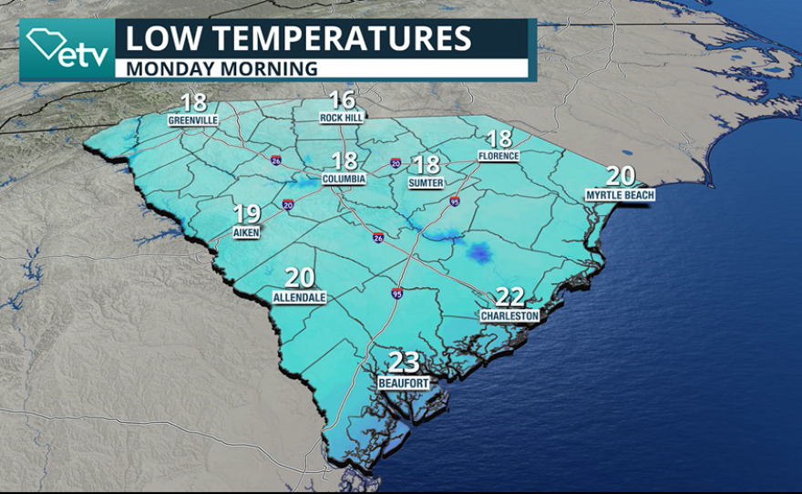
The timing of the front means residents will wake up Monday morning to the coldest conditions since last winter, with wind chill values making it feel even colder than the actual air temperatures.
Forecast models show the cold airmass will be widespread, with temperatures dipping into the mid-teens in the Upstate and the low 20s along the coast. Central portions of the state are expected to see readings in the upper teens.

Wind chill values could shave another five degrees off air temperatures, causing “feels like” readings to approach the single digits on Monday morning in some areas.
The combination of low temperatures and winds will make simply being outside hazardous, particularly for anyone not sufficiently bundled up.
Monday’s sunshine won’t help the mercury recover much, with highs only expected to reach the 30s statewide.
One of the few silver linings is that the Arctic airmass is expected to be dry, meaning there won’t be a threat for precipitation, which would fall in the form of snow.
Temperatures are expected to bottom out roughly 5-8 degrees below the coldest readings so far this season, though they are still expected to remain above record-cold territory.

The cold air invasion will make it essential to prepare the “7 Ps”: people, pets, plants, pipes, pools, protecting vehicles and practicing fire safety.
Several house fires have already been reported around South Carolina in connection with heating devices during the fall and the beginning of meteorological winter.
To reduce the risk of a house fire, the St. John’s Fire District, which serves several of the southeastern islands, reminds residents to: keep heaters at least three feet away from flammable material, use heaters only in well-ventilated areas and never leave heaters unattended or running while sleeping.
The cold wave is expected to begin easing after Tuesday as an upper-level ridge moves eastward, allowing temperatures to rebound and stay in the warm realm through the holidays.