As millions of Americans prepare to head to their holiday destinations, the weather could play a role in determining how smoothly those journeys go.
While large sections of the country will enjoy relatively quiet and mild conditions, much of the West Coast is bracing for an active stretch of stormy weather that could lead to travel delays both in the air and on the ground.
The peak holiday travel period is considered to begin Saturday and run through New Year’s Day on Jan. 1.
During the nearly two-week time period, the American Automobile Association anticipates about 122 million Americans will travel at least 50 miles from home, representing a 2.2% increase over last year’s record-setting levels.

This year’s holiday travel season follows an active stretch of weather across the country.
Heavy snowfall recently impacted portions of the Great Lakes, with communities along the I-95 corridor seeing their first measurable accumulations of the season.
The Pacific Northwest has dealt with episodes of extensive flooding, while a blast of Arctic air was significant enough to reach as far south as the Gulf Coast.
Heading into the busy travel week, most of the country will catch a break from significant weather disruptions.
Outside of the Pacific Northwest and parts of California, widespread hazards appear limited, thanks largely to a storm track positioned well north of much of the U.S.
This pattern will allow above-average temperatures to dominate from the Rockies to much of the East Coast, reducing the risk of wintry weather that could complicate holiday travel.
Weekend before Christmas forecast
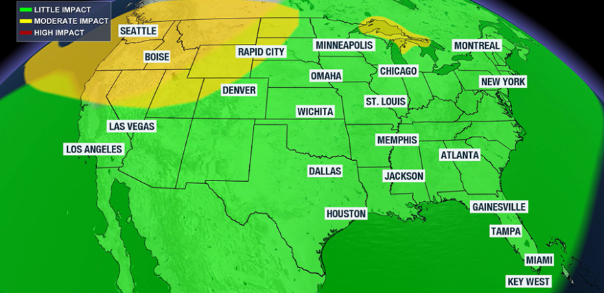
Travel impact alert: Seattle; Portland, Oregon; San Francisco; Green Bay, Wisconsin

The most active weather in the days leading up to Christmas will be focused along the West Coast and, to a lesser extent, around the Great Lakes.
In the West, an ongoing stormy pattern will continue to bring mountain snow and valley rain.
Communities around and north of San Francisco are expected to see periods of heavy rainfall over the weekend, which could slow road travel and contribute to flight delays at major airports.
Across the upper Great Lakes, a fast-moving clipper system will sweep through the region and produce snowfall.
Accumulations are expected to remain light and be confined north of Interstate 80.
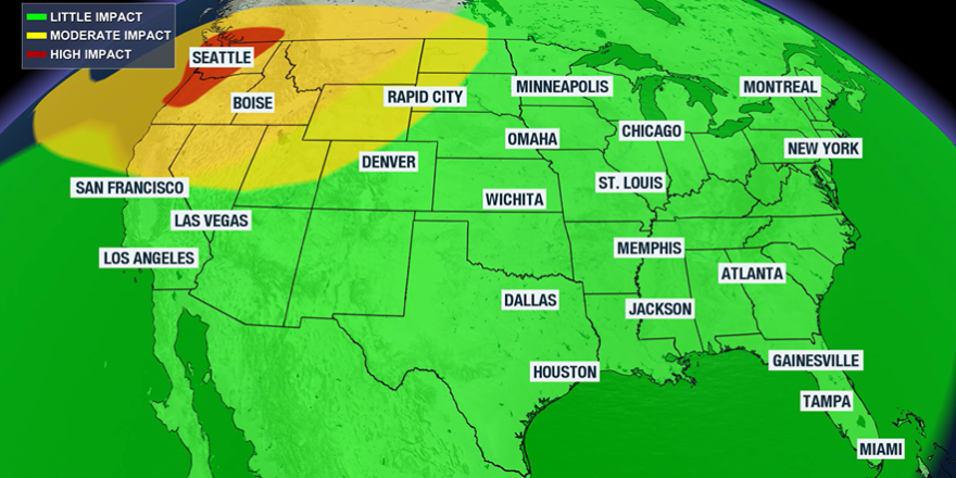
Monday, Dec. 22 forecast
Travel impact alert: Seattle, San Francisco

The start of the holiday week will largely set the tone for the days that follow.
Stormy conditions will persist along the West Coast, while most of the rest of the country experiences above-average temperatures.
Travel along and west of Interstate 5 in the western U.S. could be problematic at times due to periods of rain and mountain snow.
Flight delays are possible into and out of Seattle-Tacoma International Airport and San Francisco International Airport as waves of precipitation move through.
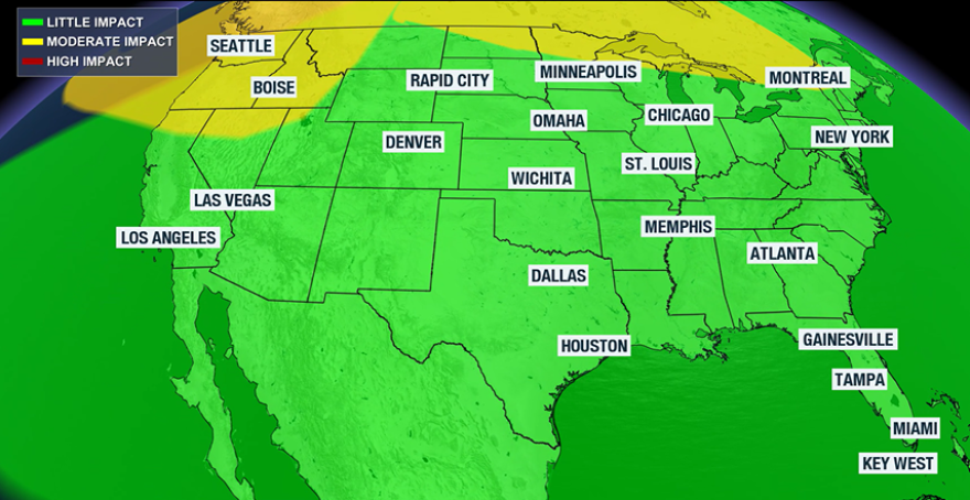
Tuesday, Dec. 23 forecast
Travel impact alert: Seattle

On the eve of Christmas Eve, much of the nation will remain warm with minimal weather-related hazards.
Pockets of cooler air will be positioned over New England and the Pacific Northwest but without needed moisture, most areas in the cold zone will be dry.
Along the West Coast, scattered rain and snow showers will continue, particularly across Washington and Oregon.
While not as intense as seen with earlier rounds of wet weather, the precipitation could still cause localized travel slowdowns.
Wednesday, Dec. 24 forecast
Travel impact alert: Seattle, San Francisco

Christmas Eve could bring the most widespread travel challenges of the week as crowds mix with the impacts Mother Nature.
Aside from a few widely scattered rain or snow showers around the Great Lakes, the primary concerns will again be on the West Coast.
Cold air in the Pacific Northwest will allow snow levels to drop fairly low, while much of California will see precipitation fall in the form as rain.
Conditions on Christmas Eve will serve as a preview of what’s to come on Christmas Day, with precipitation rates expected to intensify on the big day.

Christmas Day forecast
Travel impact alert: Los Angeles, San Diego, Baltimore and Washington, D.C.
Dec. 25 is typically one of the lightest travel days of the year, but the weather could still complicate plans in a few areas.
Heavy rainfall is likely south of San Francisco into northwest Mexico, which could lead to dangerous flooding and landslides.
Farther east, a weaker weather system will be in the vicinity of the mid-Atlantic, including the nation’s capital.
With warm air in place, most of the precipitation will fall as rain rather than snow, limiting winter weather impacts.
Because of an expansive dome of warm air across much of the country, the chances for a white Christmas will be slim for most Americans, with snow cover already on the ground being the primary exception.


