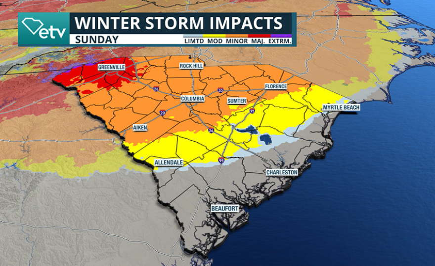
A significant winter storm is expected to impact much of the eastern half of the country, bringing a dangerous mix of precipitation that could lead to hazardous travel conditions across South Carolina from late Saturday through early Monday.
Forecast models continue to show frozen precipitation developing late Saturday, particularly along and north of the Interstate 20 corridor, as the storm system moves from southwest to northeast across the region.
While snow is expected to be heavy across the Ohio and Tennessee valleys, the primary local concern will be ice accretion rather than snowfall.
Forecast guidance indicates the potential for more than a half inch of ice north and west of I-20, an amount that could result in widespread travel disruptions.

Ice thickness of this severity can also lead to downed trees and occasional power outages, which can last for an extended period of time because of the conditions repair crews face.
Forecast models show communities such as Greenville, Spartanburg, Anderson and Rock Hill receiving the highest accumulations, while locations such as Florence and Columbia are expected to see substantially less.
Due to the threat posed by the winter storm, Gov. Henry McMaster declared a State of Emergency before the storm, which allows state agencies to mobilize resources and suspends certain regulations to ensure that emergency response equipment and supplies don't face delays.
“South Carolinians should remain aware of local forecasts and take appropriate precautions ahead of this weekend's storm, as winter weather can change quickly and create hazardous conditions with little notice,” McMaster stated. “Preparations are already underway by state agencies, and this State of Emergency ensures Team South Carolina is ready to respond and support communities as conditions develop.”

Farther south, across portions of the Lowcountry and Grand Strand, winter weather accumulations are not expected but periods of heavy rain could still lead to slick roadways.
Winter weather alerts, including Winter Storm Watches, have been issued for areas that could potentially see the highest accumulations of frozen precipitation.
The exact amount of ice will ultimately depend on temperature profiles near the surface and aloft, which can vary significantly over short distances.
At the center of the forecast is what is called "cold air damming," a shallow layer of colder air becomes trapped east of the mountains.
Where this cooler air ultimately sets up will have the greatest potential for ice accumulation across the Upstate and the Midlands.
If the cold air remains firmly in place, freezing rain and sleet could persist for an extended period, but if the cold air fails to establish itself, forecast ice totals could end up lower than what are expected.

Even after the precipitation comes to an end on Monday, hazardous conditions may persist through the upcoming workweek.
Very cold air is expected to funnel into the region behind the winter system, with overnight low temperatures potentially falling into the single digits and teens across much of the state next week.
These below-normal temperatures will allow any frozen precipitation that accumulates to linger for an extended period, increasing the risk of black ice forming on untreated roadways.
For communities placed under winter storm alerts, residents are advised to prepare in a manner similar to hurricane readiness, as it may take several days for conditions to fully improve.
Suggested preparations include purchasing food that does not require heating or refrigeration, refilling prescription medications, stocking up on heating fuel and ensuring fireplaces, stoves and non-electric space heaters are in working order.
Stay up-to-date on the latest weather impacts by following SCETV on X and on Facebook.


