-
 In a typical Atlantic Ocean hurricane season, August through mid-September is the busiest time for tropical storms and hurricanes. This season is no different.
 -
 Idalia will move into South Carolina’s Lowcountry this evening as a weakening Category 1 hurricane with sustained winds around 75 mph. Dangers stemming from a tropical cyclone not only exist during the storm, but also after it passes.
 -
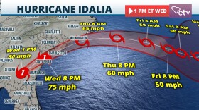 Hurricane Idalia is forecasted to reach hurricane strength as it moves inland on southeast Georgia and South Carolina coast late Wednesday afternoon.
 -
 Idalia is expected to make landfall across the Big Bend Coast of Florida as a Category 3 hurricane Wednesday morning then track into Georgia and South Carolina as a tropical storm.
 -
 Tropical Depression Ten has now intensified into Tropical Storm Idalia. The NHC is forecasting landfall as a Category 1 hurricane along the Florida Gulf Coast on Wednesday, then approach South Carolina as a tropical storm late Wednesday into Thursday.
 -
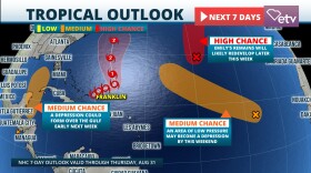 The National Hurricane Center is now marking a spot from the northwest Caribbean into the eastern Gulf of Mexico with a moderate chance for development. Tropical Storm Franklin is now becoming better organized and will likely become a hurricane over the weekend.
 -
 Hurricane season for people on the East Coast is a familiar six-month-long event, but for people on the West Coast, seeing a tropical cyclone is an unusual site.
 -
 After July was recorded to be the hottest month ever recorded, the Southeast Regional Climate Center is predicting that more records may be broken again this month.
 -
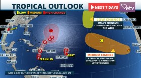 Tropical Storm Harold made landfall on Padre Island late this morning with max sustained winds of 50 mph. Franklin is still forecasted to turn into a weak hurricane this weekend.
 -
 We still have 5 areas of interest that are dominating the tropics today.
© 2024 South Carolina Public Radio

Play Live Radio
Next Up:
0:00
0:00
Available On Air Stations


