-
 South Carolina has seen just three June tropical cyclone landfalls since 1851, with no system stronger than a Category 1 hurricane.
 -
 During an average year, the Atlantic Basin sees 14 named storms, seven hurricanes and three major hurricanes. The list of names for the 2026 Atlantic hurricane season starts with Arthur.
 -
 A weather pattern change, which resulted in many communities seeing at least half a foot of rain during May, has led to improvement in the drought conditions.
 -
 Forecasters believe a strengthening El Niño pattern is likely to emerge in 2026 and continue into winter, thus influencing temperature and precipitation trends across the United States.
 -
 AAA projects that around 45 million Americans will travel at least 50 miles during the 2026 Memorial Day holiday weekend.
 -
 NOAA’s outlook for the 2026 Atlantic hurricane season predicts below-normal activity as an impending El Niño will lead to increased wind shear across the basin.
 -
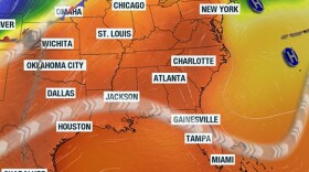 A prolonged stretch of above-normal temperatures is expected to continue across South Carolina through at least midweek as high pressure controls the weather.
 -
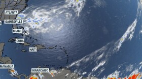 The National Hurricane Center released its first daily outlook for the Atlantic, Caribbean and Gulf on Friday which showed no tropical activity was expected over the next week.
 -
 A storm system is expected to produce rainfall and gusty winds across the Palmetto State on Thursday. Most communities will see rainfall totals from 0.25 to 1 inch.
 -
 The first named cyclone in the Atlantic basin typically forms around June 20, with meteorologists tracking the first hurricane by Aug. 11. The first named storm will be Arthur.
© 2026 South Carolina Public Radio

Play Live Radio
Next Up:
0:00
0:00
Available On Air Stations


