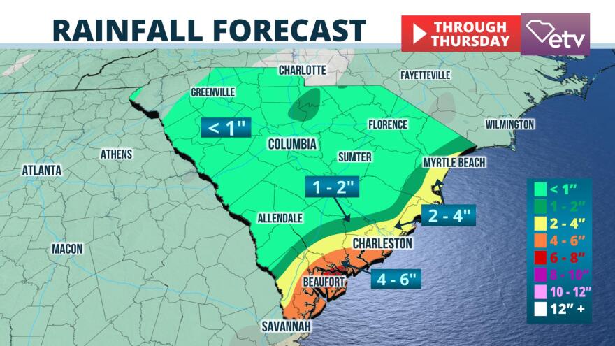
Flash flooding is possible in the South Carolina Lowcountry Tuesday night and Wednesday, thanks to multiple rounds of showers and t-storms likely to hit the same areas over a short amount of time.The National Weather Service in Charleston issued a Flash Flood Watch Tuesday afternoon for the counties of Hampton, Colleton, Dorchester, Berkeley, Charleston, Beaufort, and Jasper. The watch is in effect until 6 pm Wednesday.

The heaviest rainfall accumulation is expected in coastal areas from Charleston and Hilton Head, where 4 to 6 inches is possible. Residents from North Charleston to Myrtle Beach are likely to receive 2 to 4 inches of rain, and 1 to 2 inches of rain is expected further inland along the I-95 corridor.
The City of Charleston is taking no chances with the possible flooding. In a statement posted to their Facebook page Tuesday, the city enacted their Public Safety Operations Center in anticipation of the severe weather.
City of Charleston Emergency Management Director Shannon Scaff said, “As always, the safety of our citizens is job one. We urge everyone to stay tuned to local media for the latest weather forecast, and to exercise caution when on the roads.”
Director Scaff adds that road closures will be updated on the city’s road closure map, which can be viewed here: http://gis.charleston-sc.gov/road-closures.
A subtropical air mass has been in place over the Palmetto State for days, which has already led to a period of wet weather for many leading up to this event. A weak area of low pressure is forecast to develop along a weak frontal boundary in southeast Georgia Tuesday night, enhancing the lift necessary to produce thunderstorms. The downpours are then likely to evolve into areas of heavy rain that will move northeast along the Atlantic Coast. Rainfall rates of 1 to 2 inches per hour are possible in the stronger cells, leading to rapid runoff and possible flooding.
A much drier air mass is forecast to sweep across South Carolina Thursday, effectively shutting down the antecedent heavy rain and flash flood risk.
Meteorologist Cyndee O'Quinn contributed to this report.


