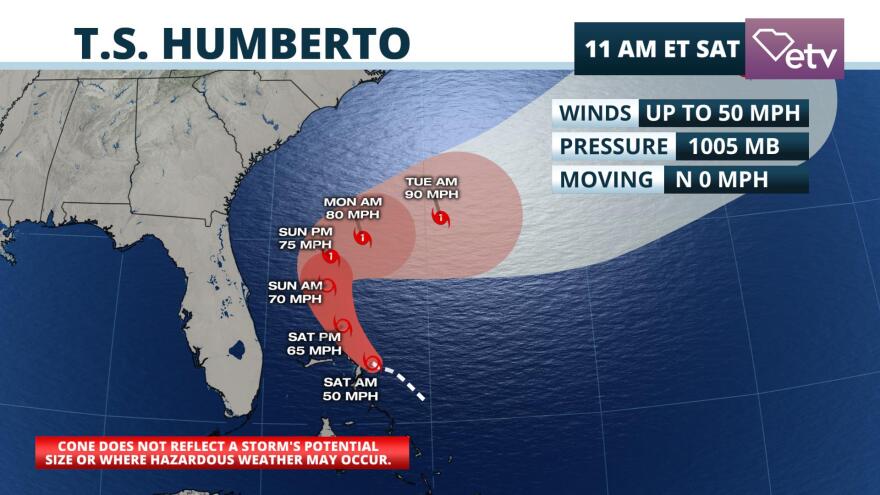
The season’s eighth named tropical storm was classified by the National Hurricane Center late Friday night, but it is no longer a direct threat to South Carolina.
Hurricane hunters then found that the tropical storm had strengthened Saturday morning, and it now has winds up to 50 mph. Strong upper-level winds from the southwest were limiting the tropical storm’s ability to become better organized. However, those winds are expected to weaken Sunday when forecasters say Tropical Storm Humberto will be poised for intensification.
Tropical Storm Humberto did not have a well-defined center of circulation until Friday afternoon. There is a much larger margin of error in a track forecast of a developing system without a center. This was quite evident when comparing model data over the past three days with the former Potential Tropical Cyclone Nine.
#ProTip - Forecast models should be used with extreme caution when a center of circulation is not well established. The spaghetti on #Humberto is a great example.#PetPeeve - Saying forecast "shifted" (so much) when it really was just premature to begin with. #FLwx pic.twitter.com/LCkejjr00l
— Jeff Huffman (@HuffmanHeadsUp) September 14, 2019
Now that confidence has increased that Tropical Storm Humberto will not directly affect the United States, our attention turns to the rest of the tropical Atlantic. As of Saturday morning, the National Hurricane Center was monitoring three tropical waves with some probability of developing.

None of the disturbances being tracked are an immediate threat to the Southeast, although long range forecast data suggests one or two of them in the central Atlantic will have an opportunity to become a formidable tropical storm or hurricane in the next week or two. Even though the climatological peak of hurricane season has passed, historical records show there is an elevated risk of hurricane landfalls in South Carolina through early October.


