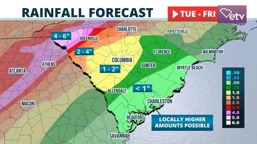
Multiple weather-related hazards are possible Wednesday night and Thursday over a large portion of the Palmetto State.
First round Wednesday night
An increasingly warm and humid air mass will surge northward across the state Wednesday afternoon into Thursday. A fe showers may develop as soon as Wednesday morning, especially over the Upstate and Midlands. The showers and thunderstorms are then likely to become more widespread Wednesday night.

This initial round of rain may be heavy and lead to areas of flash flooding, particularly across the South Carolina Upstate late Wednesday night. Forecasters at NOAA's Weather Prediction Center are projecting 3 to 5 inches of rain from this storm system west of Columbia to Rock Hill line, which may lead to pockets of flash flooding.
A line of thunderstorms is more likely to organize along and ahead of the cold front in Georgia Wednesday morning. Heating of the day and very strong winds through the atmosphere will foster an environment that is favorable for a gradually strengthening squall line as it sweeps across the state during the afternoon and evening hours. Our best estimate of time of arrival of the squall line is as follows:
Greenville/Spartanburg Noon - 3 PM
Aiken 6-9 PM
Rock Hill & Columbia 7-10 PM
Orangeburg & Florence 8-11 PM
Myrtle Beach & Charleston 10 PM - 2 AM Friday
The Storm Prediction Center has issued a "slight risk" (level 2 out of a possible 5) for most of the state. Their primary concern is for damaging wind gusts with this fast-moving squall line. A few brief tornadoes are also possible.
The line of thunderstorms is expected to exit the state prior to dawn Friday. A more tranquil weather regime is forecast to follow the strong front in time for the weekend.


