Update as of 3:00 PM Tuesday:
The National Weather Service has canceled the Flash Flood Watch it had in effect over the Upstate. Scattered showers or an isolated strong thunderstorm are still possible Tuesday evening thanks to the passage of a weak front. Overall, a brief period of drier weather is expected on Wednesday before another cold front arrives late Wednesday night and Thursday with more widespread rain and thunderstorms.
Update as of 10:30 AM Tuesday:
A lull in the rain has developed. Flash Flood Watches remain in effect for Anderson, Greenville, Oconee, and Pickens counties until 7 PM. The National Weather Service in Greenville says that despite the break in the rain, some runoff will be routed to the main stem rivers from the rain Monday night and early Tuesday morning. They also said another band of showers and thunderstorms may develop this afternoon that would produce a rapid response on small streams in the area. This band may produce strong winds in a few isolated locations.
Forecast models are projecting lower rain amounts region-wide tonight into Wednesday, but scattered showers are still possible. Another round of rain and thunderstorms is still likely late Wednesday night through Thursday with an approaching cold front. For this reason, the National Weather Service says they are likely to issue another Flood or Flash Flood Watch because of the saturated ground and high river and stream levels. A few strong thunderstorms may also develop Thursday morning if the air becomes unstable enough.
Drier conditions are still forecast for Friday into the weekend statewide.
Original article from 10:15 AM Monday:
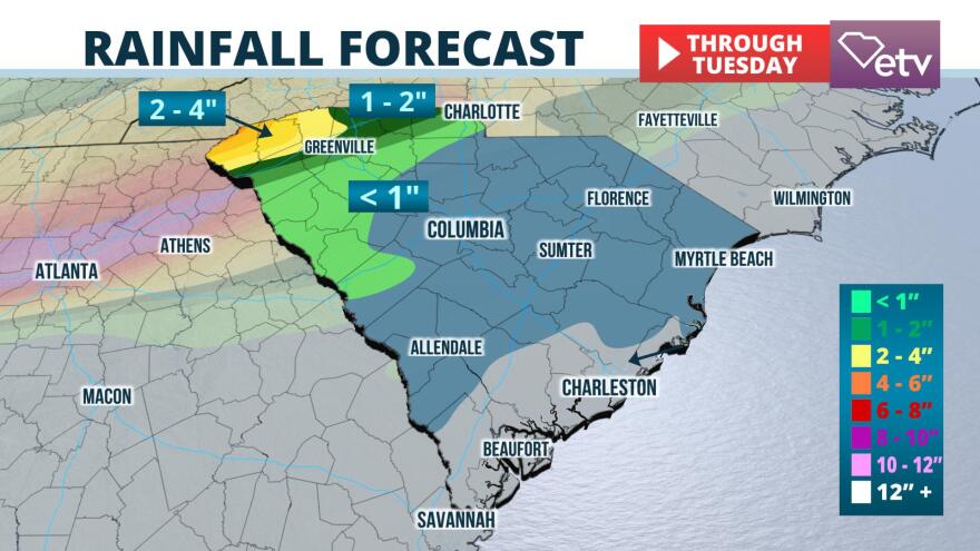
Several more inches of rain over the Upstate region is likely to trigger flash floods Monday night into Tuesday morning thanks to a consistent feed of moisture originating from the tropical Pacific Ocean and the Gulf of Mexico.
The added rain comes after a large portion of the Upstate received between 3 and 7 inches of rain over the past week, triggering flash floods last Wednesday night and Thursday. Analysis from a blend of radar data and rain gauges reveal that northern parts of Pickens, Greenville, and Spartanburg counties have received more than 3 times their average rainfall over the past 30 days. Similar departures have been observed in McCormick and Greenwood counties.
Rain is already spreading back into the western Carolinas and northeast Georgia this morning. The rainfall will pick up in intensity this afternoon into tonight and persist into Tuesday. Flooding will be possible. More rain is expected on Wednesday and Thursday. #gawx #scwc #ncwx pic.twitter.com/67Nwn9CFbL
— NWS GSP (@NWSGSP) February 10, 2020
2 to 4 inches of new rain was expected Monday afternoon through Tuesday evening, prompting the National Weather Service in Greenville to issue Flood Watches in Oconee and Pickens counties through Tuesday evening. They say this amount of rain may lead to new flooding and worsen conditions in areas that have not yet recovered from flooding last week. Also, they are warning about the potential of flooded roadways and the increasing risk of landslides.

Several disturbances high in the atmosphere are embedded within a west-southwesterly wind flow that traces all the way back to the Pacific Ocean, near the Baja Peninsula. These disturbances, combined with the higher terrain of the Upstate, cause the air to rise and produce more clouds and precipitation. One such disturbance over Texas on Monday morning is on course to reach the Upstate Monday night and depart by Tuesday afternoon. Occasional showers are possible Tuesday night into Wednesday, but the most reliable models show less frequent downpours during this time.
A final round of rain and thunderstorms are likely Wednesday night into Thursday morning along and ahead of a cold front. It is unclear how much additional rain may fall, but additional flooding is possible if the rain becomes heavy or persistent enough. A few gusty thunderstorms may occur because of strong winds throughout the atmosphere; however, widespread strong storms are presently unlikely.
Several days of drier weather are expected starting on Friday and lasting through next weekend if the latest model projections hold true.


