It has been an abnormally busy season hurricane season in many respects: the Gulf coast is bracing for its eighth landfalling tropical storm or hurricane in a season. If Zeta landfalls as a hurricane, it would tie the Continental U.S. record of 6 landfalling hurricanes in a single season, last set in 1985 and 1886.
#Zeta is forecast to make landfall as #hurricane along northern Gulf Coast tomorrow. If it does so, it will be 6th continental US landfalling hurricane this year, tying 2020 with 1886 and 1985 for most continental US landfalling hurricanes in a single Atlantic season on record. pic.twitter.com/evUB90Dxzt
— Philip Klotzbach (@philklotzbach) October 28, 2020
Zeta regained hurricane strength early Wednesday morning over the warm waters of the central Gulf of Mexico. It is forecast to strengthen more and may attain category 2 status prior to landfall along the Louisiana Gulf coast late Wednesday afternoon. Tropical storm force winds are expected to arrive along the Gulf coast from Louisiana to the western Florida Panhandle between mid-afternoon and sunset Wednesday before subsiding in the hours prior to dawn on Thursday. Hurricane force winds are most likely in the hurricane warning area over Louisiana and Mississippi early Wednesday evening.
The storm’s fast forward motion is expected to spread tropical storm force wind gusts well inland over Mississippi, Alabama, and Georgia early Thursday morning. These winds are capable of producing power disruptions to areas far away from the coast. Pockets of flash flooding are possible, but the quick movement of the storm should limit total rainfall amounts to around 1 inch in the western Florida Panhandle to as high as 2 to 4 inches in a swath from southeast Louisiana to Mississippi, Alabama, north Georgia, and the Upstate of South Carolina. Flash Flood Watches have been issued in the mountains of South Carolina west of Interstate 85, where the higher terrain makes flooding more probable.

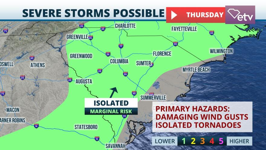
The rain and wind tied to Zeta is forecast to arrive in the Upstate of South Carolina in the hours preceding dawn on Thursday before diminishing around midday Thursday. A cold front following Zeta may bring another round of scattered thunderstorms statewide Thursday afternoon.

Strong winds throughout the atmosphere and daytime heating may result in a couple of strong storms with a brief, isolated tornado threat. The scattered showers and storms are expected to move offshore shortly after sunset Thursday as the cold front moves into the Atlantic waters.


