

South Carolina will experience some weather changes this week as a cold front slowly approaches the state. This front will bring more stable weather, especially across the Upstate and Midlands, from Monday night into Tuesday. Another weak boundary is expected to move through the northern part of the state on Thursday, bringing the possibility of a brief passing thunderstorm. Overall, conditions will improve through the middle and latter part of the week. However, as sunshine increases, temperatures are expected to climb across much of the state. The warmest temperatures will be found across the Midlands, Lowcountry, and Pee Dee region from Wednesday through the end of the week.
Rounds of showers and storms peppered across the state. The heat bulds in South Carolina for the second half of the week. pic.twitter.com/I7UaTzT0oq
— SCETV (@SCETV) June 8, 2026
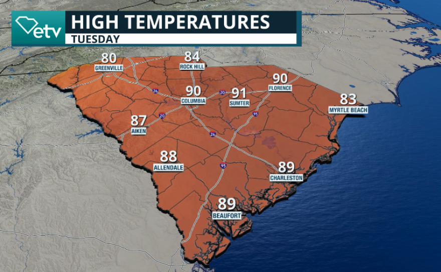
Tuesday
Tuesday morning will be wet across the Upstate, with scattered showers and an isolated thunderstorm moving through the region. By the afternoon, skies will become partly sunny, although a brief shower or thunderstorm cannot be ruled out. As the front approaches the northern Midlands, isolated showers and thunderstorms may develop from late morning into the afternoon. The Pee Dee region could also see a brief thunderstorm, but coverage is expected to remain very limited.
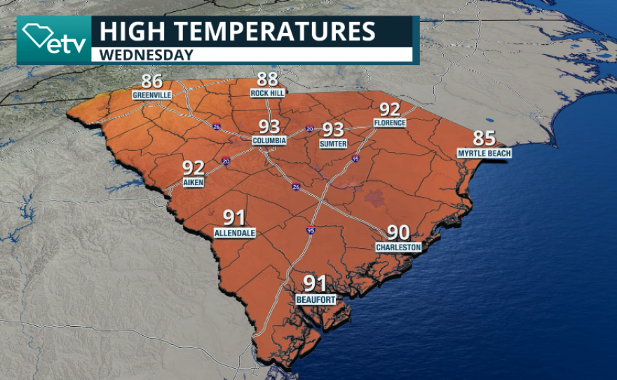
Wednesday
By Wednesday, another trough may approach the Upstate and Midlands. This could lead to a line of showers and perhaps a few thunderstorms developing across the Midlands during the afternoon, while coastal areas remain mostly stable. The line of precipitation will likely weaken in the evening as daytime heating subsides, with skies gradually clearing overnight.
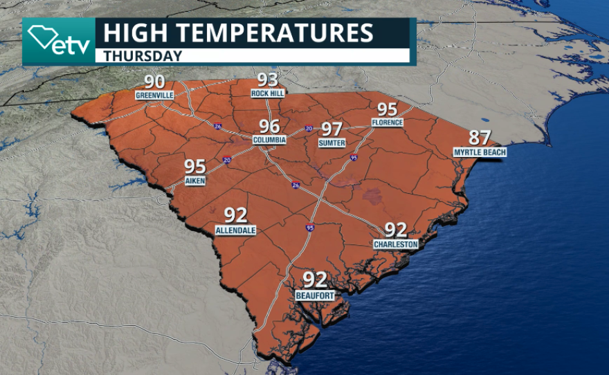
Thursday
Thursday will bring another chance for scattered showers, particularly across the Midlands and Lowcountry. While a few thunderstorms are possible, the primary weather concern from Wednesday through Friday will be the heat.
The temperatures soar
High temperatures are expected to reach the lower to middle 90s across the Midlands, interior Pee Dee, and Lowcountry. Some locations could climb into the mid-90s. Across the Upstate, highs will generally range from the upper 80s to lower 90s. Winds through the middle of the week will mainly come from the south across much of the state, while coastal areas will see south-southeasterly winds.
Beach and Rip Current Concerns
With winds blowing directly onshore through midweek and into Thursday morning, there is a good chance that the rip current risk will increase along South Carolina beaches. If you plan to visit the beach during the middle of the week, exercise caution. Swim near a lifeguard whenever possible, and avoid entering the water if conditions appear dangerous. Please read about rip currents and what to do in case you get caught in one here.
