-
 A watch means conditions are favorable and it’s time to prepare, while a warning means dangerous weather is occurring or will occur and it’s time to act.
 -
 Colorado State lowers its 2026 Hurricane Season forecast due to a strong El Niño developing during the season. What does this mean?
 -
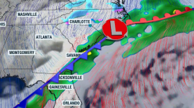
 Front slides in tonight through South Carolina. Temperatures drop slightly, then ehat ramps up. Winds will shift.
 -
 Families and caregivers of neurodivergent children face unique challenges during emergencies. Now, a team of moms is partnering with the cities and organizations to host an autism-friendly emergency preparedness workshop—showing how a specially designed backpack with tailored tools can help reduce stress when it matters most.
 -
 Flash flooding claims more than 140 deaths annually statewide, and this is just one of the three types of flooding that impact the Palmetto State.
 -
 The National Weather Service advises that a Tornado Watch is in effect until 1 p.m. Thursday for a number of counties in the state. Meteorologists also are keeping track of tornado warnings and other severe weather alerts.
 -
 The South Carolina Emergency Management Division is partnering with the National Weather Service and the South Carolina Department of Natural Resources to promote awareness of the dangers associated with severe storms, tornadoes and flash flooding, while urging South Carolinians to take appropriate steps to stay safe.
 -
 It’s the time of the year, ding! Your car’s tire pressure sensor light is on! You can blame it on the weather.
 -
 Two cold fronts are expected to cross the Palmetto State this week. Temperatures will remain well-below-average to end the week and into the weekend. Strong winds, too! There is a warm-up on the horizon.
 -
 The Geminids is the most active meteor shower of the year and it peaks tonight. Will clouds allow visibility? If not, could they still be watched later this week?
© 2026 South Carolina Public Radio

Play Live Radio
Next Up:
0:00
0:00
Available On Air Stations


