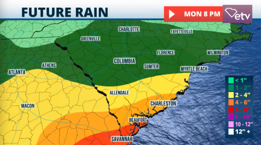
The week will end with increased shower and thunderstorm activity across much of the Southeast. A low-pressure system entering the region will lead to plenty of moisture, which will cause instability. The moisture channel will continue streaming in from the Gulf of Mexico across Florida and the Carolinas throughout the weekend.
Parts of South Carolina are expected to experience heavy rainfall. Some storms could turn severe, producing damaging winds and hail. Please stay tuned. pic.twitter.com/bfEh0xcuMJ
— South Carolina Public Radio (@SCPublicRadio) May 8, 2025
Wednesday has remained mostly unstable across sections of South Carolina. The meandering stationary front and a low-pressure system moving in the upper atmosphere have brought showers and isolated storms from the wet east across the Palmetto State.

On Thursday, there’s a risk for some isolated severe storms, mainly in the late morning through the afternoon, affecting the Midlands and the coast. By the evening, more rounds of isolated severe storms could move across the Upstate and the Lowcountry.

The weather remains unstable for Friday, and we will continue with that marginal severe weather risk across most of South Carolina. Expect showers and thunderstorms that will continue moving from west to east. The most significant risk with thunderstorms that could turn severe between Thursday and Friday is damaging winds of at least 60 mph and small to medium hail.

For the start of next week
We will continue to monitor a low-pressure system that could form across the eastern Gulf of Mexico. This low-pressure system will continue to keep the moisture flow across the southeast and will likely increase the chance for showers and thunderstorms for the beginning of the week. The pattern is becoming more typical of May with increasing rain and storm activity as the temperatures continue to rise. These rains could dent the drought. We will continue to bring you updates about the drought situation in South Carolina. Remember, new releases by the US Drought Monitor are published on Thursday mornings, but the data runs from Tuesday to Tuesday. The next release that could show slightly bigger improvements will likely be for May 15.

