A passing cold front will finally sweep away the unsettled weather South Carolina has had for the last week. This cold front is courtesy of the same low-pressure system that will impact the Northeast on Thursday and Friday.
🚨#BREAKING: Heavy rain across Western North Carolina has caused a large rockslide and flooding along the newly rebuilt I-40 highway.
— Matt Van Swol (@matt_vanswol) June 18, 2025
The highway is currently closed near the TN/NC state lines. Multiple cars and an 18-wheeler were stuck in the mud. pic.twitter.com/SL1ejzDel5
🚨 I-40 West Closed 🚨
— NCDOT I-40 (@NCDOT_I40) June 18, 2025
📍 Exit 20 heading to Tennessee
🚫 Avoid the area
📲 More: Visit https://t.co/ow6udr9YWp
📸 Pic taken at 7:30pm tonight pic.twitter.com/AR7zwlQEgd
The cold front produced damaging winds across western and middle Tennessee. Luckily, this front is weakening as it moves east, and most of the worst weather will be confined closer to the storm's center. The northern fringe of South Carolina northward is likely to experience weather on Thursday with the chance for damaging winds and tornadoes.
Are you tired of the active weather? A cold front will sweep all the rains & storms away. We´ll trade the storms for heat!
— South Carolina Public Radio (@SCPublicRadio) June 19, 2025
The last batch of strong to isolated severe storms comes on Thursday for the Palmetto State, with damaging winds as the main risk.https://t.co/cUFX1pHUjB pic.twitter.com/1BrVvpMzkA
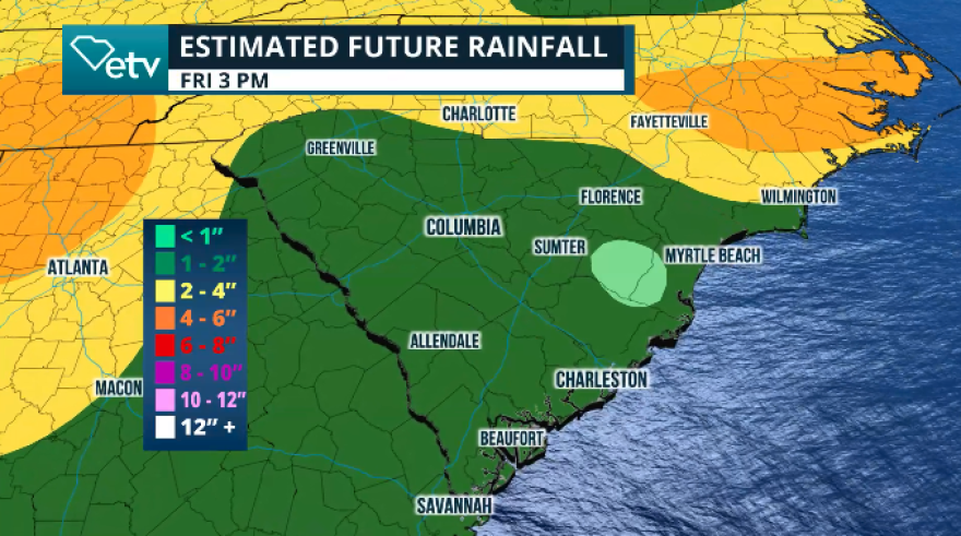
Juneteenth starts with wet weather across Upstate. Showers should be moving in from the west by 10 a.m. and tracking east, through the Midlands and coast throughout the day. Storms are not expected to be organized, but there is enough instability in the atmosphere to produce intense storms that could bring strong and damaging winds, especially those that produce downdrafts. Downdrafts are those storms that hold lots of moisture and create strong winds as all the torrential rains fall from the clouds. Any places under these downdrafts can accumulate high rainfall in a short amount of time. Overall, we are not expecting flash floods, but know that there could be areas with ponding as the ground is well saturated from recent rains. Between 1 and 2 inches of rain are expected Thursday through Friday afternoon.

By the evening, most of the shower and thunderstorm activity will focus mainly on the Pee Dee and Lowcountry. The cold front will lose its punch and speed, fizzling out as the day progresses on Friday. With enough energy left, there could still be some isolated storms, not severe, or showers on Friday over the coastal areas of South Carolina.
Warming temperatures are expected through the weekend and into next week. Highs should reach the mid 90s this weekend. pic.twitter.com/UjePdHfFaA
— NWS Columbia (@NWSColumbia) June 17, 2025
Hot temperatures are on the way!
The weekend will become toastier as temperatures are forecast to reach the low to mid-90s. Hotter days are to come, though. Monday and Tuesday are forecast to be the hottest days next week with highs that could come close to the triple digits across the Midlands and into the upper 90s across Upstate, Pee Dee, and Lowcountry. Make sure to stay cool and hydrated. Read here for more heat safety tips


