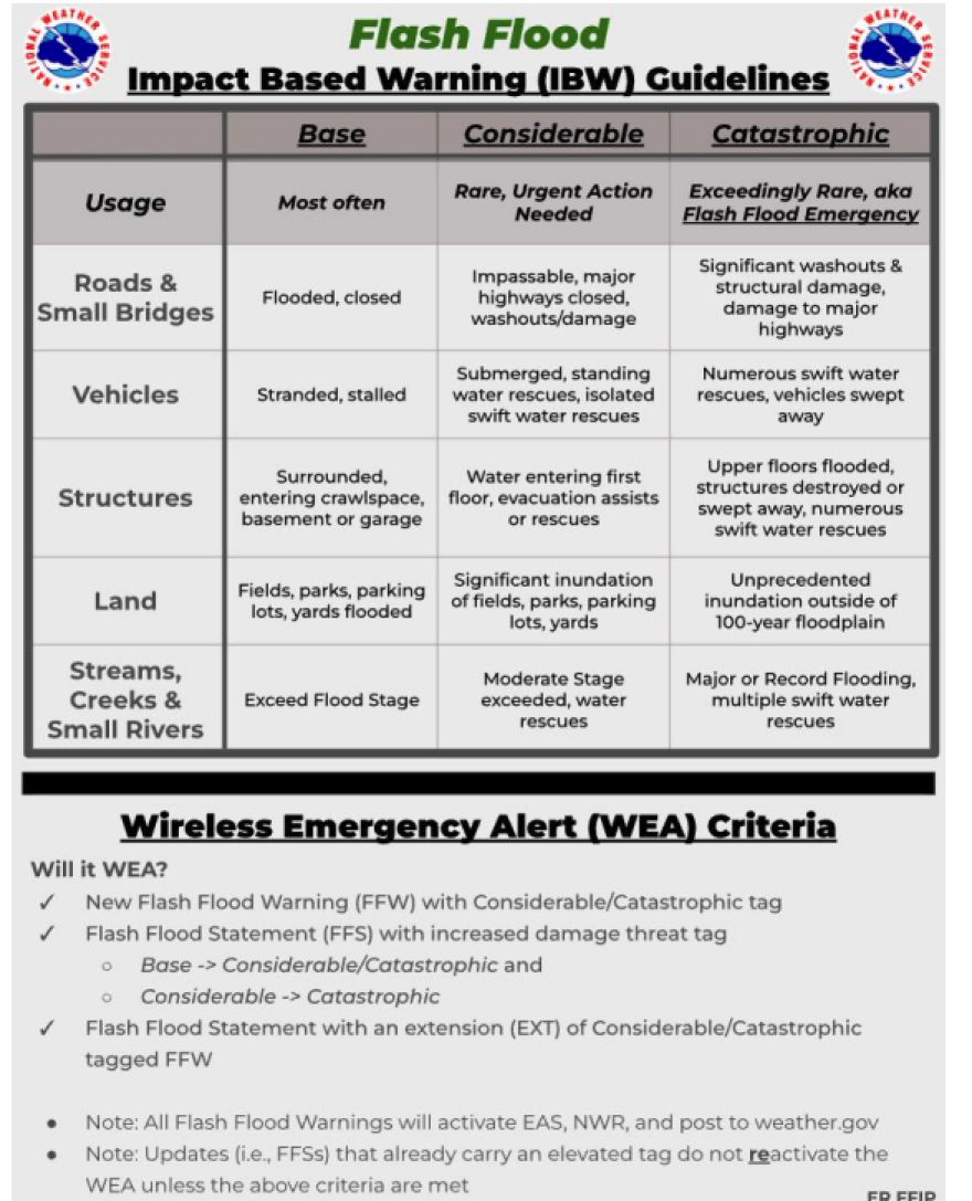
It is essential to know weather terminology, but what will help you understand the gravity of a particular situation is to understand the reason why the local National Weather Service office issues a specific alert. Flood alerts can be complex, but the National Weather Service is working to simplify them, aiming to reduce confusion and ensure the public takes them seriously, acts correctly, and responds promptly.
A flash flood occurs when heavy rainfall exceeds the ground's ability to absorb it.
A flash flood is a rapid flooding of low-lying areas caused by intense rainfall, typically occurring within six hours of the rainfall
The National Weather Service in Charleston, which is responsible for the Lowcountry, has revised the criteria it uses to issue its base flash flood warnings. Although warnings will be issued for less severe flooding situations, it will help the public receive clearer information and allow them to take action accordingly. For situations where a previous flood advisory would be issued, indicating that some roads may be flooded or minor flooding is expected, a flash flood warning will now be issued.
Current flash flood event criteria:
- Water entering an inhabited structure, such as a home or business
- One or more paved roads washed out and/or damaged (two or more dirt roads)
- Vehicle swept off the road by floodwaters
- A river or stream gauge exceeds its Moderate flood stage
- A dam or levee failure that is occurring or is imminent
New flash flood event criteria:
- Multiple roads or intersections are flooded and closed to traffic
- Vehicles stranded and/or stalled in flood waters
- Structures surrounded by flood waters or flood water entering the crawlspace, basement, or garage
- A non-forecast point river gage exceeding its Minor flood stage
- Dam or levee failure that is occurring or is imminent (typically handled with a Considerable Flash Flood Warning tag)

Please note that the Base Flash Flood Warning in the diagram above will not activate the Wireless Emergency Alert (WEA) on your phones; however, it will activate the Emergency Alert System and the tone alert on NOAA Weather Radios. These are the most common types of flash flood warnings issued by the Charleston NWS office, typically remaining in effect for 3 hours with updates every 90 minutes. These types of floods are not expected to be life-threatening or cause major damage.
All alerts will be sent out when a considerable tag is added to the flash flood warning. These are the types of floods that cause damage and could be potentially fatal.

A catastrophic tag would still prompt a flash flood emergency, as it has, nothing changes with this alert. This is the most severe flash flood warning that can be issued. It activates and sends alerts to all devices, including your phones and NOAA Weather Radios. These are reserved for rare events, such as the October 2015 flood in Charleston, which poses a particularly high risk to life and property.
These changes are likely to affect the number of flash flood warnings issued in populated urban areas, as the criteria will be easier to meet, potentially leading to an increase in their issuance due to a greater impact. At the same time, rural areas will likely maintain the exact amount and continue to receive flood advisories.

It is crucial to know your risks. Not all flooding develops the same, and your area could be impacted by recent events such as heavy rains that have left the ground already saturated or drought, which would make rainfall harder to drain. There are also rivers and creeks in South Carolina. Be informed about their levels and how they move upstream and downstream. Lastly, ensure you have at least three methods for receiving weather alerts. A NOAA Weather Radio is a valuable tool to have, as it does not rely on the internet or a telephone signal. You need to set it to your location, and it will emit a sound and flash a light to transmit the weather message for your area. Read more about NOAA Weather Radios here


