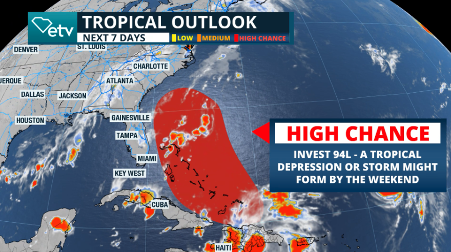
While the remnants of Gabrielle impact the Azores and Humberto continues to crawl north of the Caribbean, slowly becoming better organized, we shift our attention to Invest 94L. This is the tropical disturbance that has produced numerous showers and thunderstorm activity over Puerto Rico, and on Thursday, left a very wet day across the Dominican Republic and Haiti.
The system will continue to move slowly over Hispaniola. Still, its center is forecast to merge north of Hispaniola and once over Turks and Caicos and the southern portion of the Bahamas, which is flat territory with little friction, is likely to become Imelda. It should become better organized by Friday, but it can be named as late as Saturday. Regardless, we are closely monitoring this system, as it can impact parts of the Southeast, specifically the Carolinas, between late Monday and early Tuesday morning.

It seems like Imelda will be moving a bit faster toward the north, escaping from Humberto and staying far enough not to allow the Fujiwhara effect to happen. If Imelda picks up speed to the north, it will also lose the push or nudge the incoming front could give it. Therefore, Imelda could come straight from South Carolina. As you may notice, numerous factors are at play right now, and timing, in particular, is crucial for the overall trajectory and impact.
Could there be direct impacts on South Carolina?
The chance of direct impacts on the United States is becoming clearer. If Imelda lands in South Carolina, it would be the second storm to impact the Carolinas directly. Although it may not be on many people's minds due to the lull period the Atlantic experienced, Tropical Storm Chantal made landfall in North Carolina on July 6 with maximum sustained winds of 60 mph.

Once the system develops a well-defined center of circulation and enters the Gulf Stream, future Imelda could gain strength, and we could be referring to a hurricane by early next week.
We are closely monitoring Invest 94L, which is likely to become Imelda.
— SCETV (@SCETV) September 26, 2025
Lots of factors are at play in the forecast. Stay tuned!
There could be impacts to South Carolina. pic.twitter.com/ZIcBnvkjLh
South Carolina residents and visitors need to pay close attention to the forecast this weekend. We will continue to bring you updates here and fine-tune the forecast. If you are on the South Carolina Coast, this weekend could mean a preparation weekend. Any watches or warnings will likely be issued over the weekend, and it will be time to start acting on the plans you should already have in place. We will bring you another update by Friday evening.
Vigilamos de cerca Invest 94L (la que se ve sobre República Dominicana) que probablemente se convertirá en Imelda. Hay muchos factores en juego en el pronóstico. Condiciones marinas estarán empeorando para la costa sureste del país. ¡Estén atentos! pic.twitter.com/fQpx6tcEC1
— Irene Sans (@IreneSans) September 26, 2025


