

South Carolina will experience two cold fronts that will reinforce cold air across the area. Strong winds, mainly on Thursday across the Upstate and Midlands and then on Friday across the coast, will bring strong wind chills, especially overnight. A second cold front will push through the region late Friday into Saturday, keeping temperatures below average for this time of year. Expect a gradual warm-up for the beginning of next week.
Got rain? It was thanks to the system pushing through the state. There could be some icy conditions late this evening across the northern Midlands and northern Pee Dee. Another front arrives on Friday. pic.twitter.com/SCGUChfn0H
— South Carolina Public Radio (@SCPublicRadio) February 4, 2026
By sunset Wednesday, there were still some isolated downpours impacting the Midlands. While the heaviest showers were mainly focused across the Pee Dee, most of the showers will continue to push to the northeast, and expect the showers to continue to impact the northeastern portion of South Carolina at least through midnight. Temperatures are also falling, and although most of the moisture will try to move out of the way, there could be some freezing rain impact in the northern portion of the Midlands. As cold air filters in, freezing rain may develop overnight, making conditions dangerous during the morning commute.
Leftover moisture could linger through the morning hours across the Upstate, which translates to a few flurries falling over the area on Thursday morning. Some light precipitation will still impact the Pee Dee and the Lowcountry through the noon hour on Thursday. As the cold air moves toward the coast, there will still be cold air filtering in, which could bring a few flurries along the Midlands around noon on Thursday.
Some wintry mix is possible across the northern Midlands tomorrow morning. Relatively warm surface temperatures should prevent much in the way of impacts but keep an eye out for any forecast updates. pic.twitter.com/ITaMpfJbTT
— NWS Columbia (@NWSColumbia) February 4, 2026
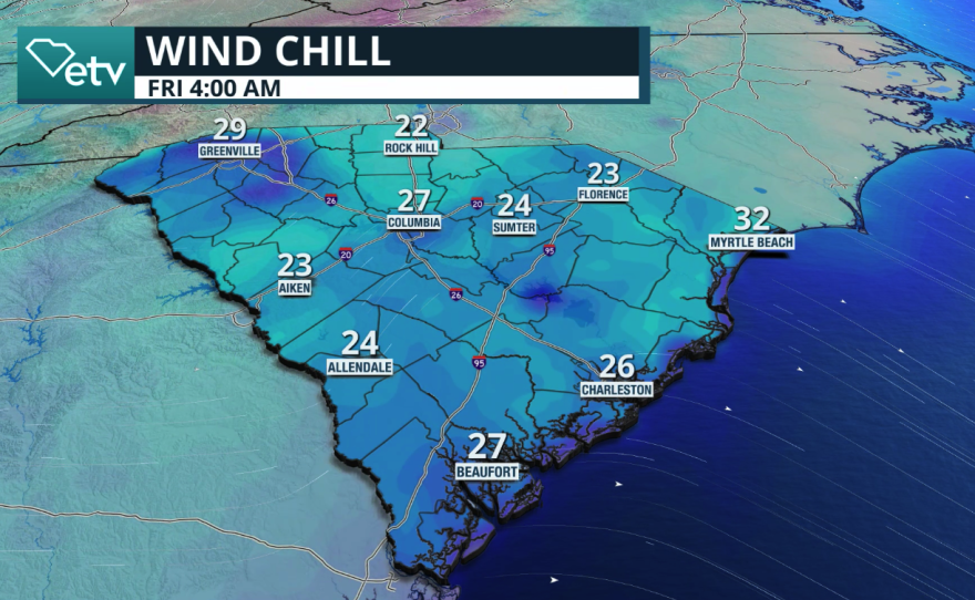
The wind will be picking up on Thursday and Friday. The strong winds will make the temperature feel much colder than the thermometer indicates. Thursday morning temperatures will remain around the mid-30s for the Pee Dee while in the low 40s across the Lowcountry. Temperatures are slightly below freezing along the Midlands and into the upper 20s across the upper Midlands and the northern upstate.
On Thursday afternoon, with clouds lingering and precipitation in some areas, temperatures will remain on the cold side. Highs could be as low as 20° below average for this time of year. Highest across the other half of the state will remain around the mid-30s, while the southern Midlands and the low country will remain in the low 40s.
Keep in mind that these temperatures will feel colder due to strong winds, primarily from the north. Gust could be as high as 25 mph, especially across the Midlands and the coast. On Friday, the wind will remain strong, with the strongest winds focused mainly across the Upstate, Columbia, and the Lowcountry. Gusts could be as high as 30 mph at times. As for Friday, we will wake up to cold temperatures across the Upstate. Temperatures will be around the low to mid-20s. The Midlands will remain in the upper 20s. The Pee Dee will wake up the temperatures in the upper 20s, and the Lowcountry will be around the freezing mark.

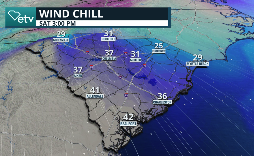


The winds will shift late Friday into Saturday. As the wind shifts mainly from the southwest, expect temperatures to respond accordingly. Although Friday will start with cold temperatures. In the morning, the afternoon will warm up nicely into the 50s across the entire state. In fact, parts of the southern Midlands and Lowcountry will reach around 60°.
The next cold front
The next cold front and low-pressure system will be pushing through South Carolina early Saturday morning. The winds will shift and strengthen on Saturday. Most of the precipitation will stay away from the state. There could be a few more clouds affecting the Upstate, and another round of rain is expected in the Midlands on Friday ahead of the cold front.
The positioning of this low-pressure system in the cold front will not allow a major cooldown across the Palmetto State. In fact, a high-pressure system will rapidly sink over the state, calming winds on Sunday, and temperatures will gradually warm up for the start of next week.