-
 Helene will stay west of South Carolina, but the periods of heavy rains, winds, and tornado risk continue overnight into Friday.
 -
 Tropical storm-force winds are expected on Thursday across South Carolina, and the weather will quickly deteriorate as Helene approaches Florida.
 -
 The National Hurricane Center issues a tropical storm warning for the northern South Carolina coast. Heavy rains and gusty winds.
 -
 A low-pressure system off the coast of South Carolina has a medium chance of developing within the next 2 days. Heavy rains and dangerous seas are expected to continue.
 -
 Rounds of rain will keep the weekend mostly wet with various systems nearby or approaching. The coast will deal with the highest rainfall.
 -
 Yes, tsunamis, although with low frequency, can happen and affect the East Coast. They would be triggered by different mechanisms.
 -
Just in case you get an alert on your phone today, the National Weather Service is testing tsunami alerts along the East Coast and Gulf Coast at 3 p.m., don't worry!
-
 Ernesto will continue to gain strength as it moves again from the Caribbean and remains far away from South Carolina, but large swells and rough surf are possible this week and through the weekend.
 -
 The next name system is Ernesto and luckily for the U.S. it is turning northward and staying well away from South Carolina.
 -
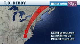 Debby´s winds weaken, but rainfall will continue to affect areas north of South Carolina. There could be an additional 1 to 3 inches of rain across the Lowcountry and Pee Dee.
© 2026 South Carolina Public Radio

Play Live Radio
Next Up:
0:00
0:00
Available On Air Stations


