-
 Fire weather alerts have been issued for South Carolina and the Southeast as strong winds, low humidity and dry conditions produce critical fire weather conditions through the weekend.
 -
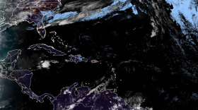 The National Hurricane Center is rolling out upgraded products for the 2026 hurricane season, including a redesigned cone graphic, new storm surge tools and improved access for mobile users.
 -
 The 2026 vernal equinox was set to occur on March 20 at 10:46 a.m. EDT, marking the astronomical start of spring with nearly equal amounts of daylight and darkness.
 -
 The timing of the last frost or freeze can vary widely across the Palmetto State. In warmer years, the last event often occurs in March, while in colder years, frosts and freezes can happen in May.
 -
 An unusually strong cold snap is bringing freezing temperatures to much of South Carolina. Temperatures are expected to drop into the 20s and 30s.
 -
 Severe storms rolled through South Carolina on Monday, producing sporadic wind damage.
 -
 Strong thunderstorms could impact parts of South Carolina late Sunday and on Monday as a powerful weather system moves through the region.
 -
 Flash flooding claims more than 140 deaths annually statewide, and this is just one of the three types of flooding that impact the Palmetto State.
 -
 The National Weather Service advises that a Tornado Watch is in effect until 1 p.m. Thursday for a number of counties in the state. Meteorologists also are keeping track of tornado warnings and other severe weather alerts.
 -
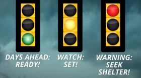 South Carolina officials are highlighting storm preparedness and communication during the state's weather safety week.
© 2026 South Carolina Public Radio

Play Live Radio
Next Up:
0:00
0:00
Available On Air Stations


